The Gobi Desert covers 1,295,000 square kilometers of rocky plateaus and gravel plains across southern Mongolia and northern China. Only five percent of this rain shadow region contains sand dunes, while the rest features deep ice gorges, red sandstone cliffs, and ancient Silk Road oases.
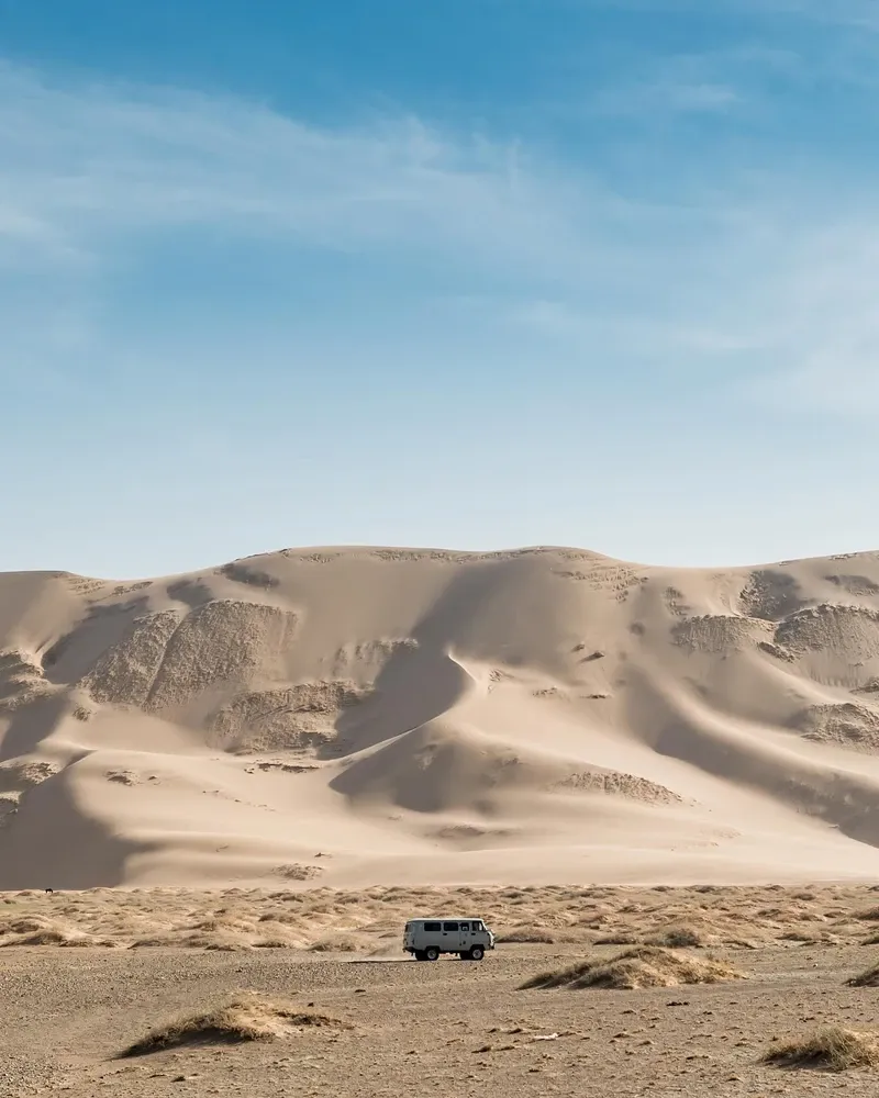
The Himalayan Mountains block moisture-laden winds from the Indian Ocean, creating a 1,295,000-square-kilometer rain shadow across southern Mongolia and northern China. This expanse forms the largest desert in Asia, measuring 1,600 kilometers from east to west and 800 kilometers from north to south. Bare rock and semi-arid steppe dominate the landscape. Sand dunes cover just five percent of the terrain. Visitors cross endless gravel plains to reach isolated geological anomalies like the 300-meter-high Khongoryn Els dunes or the deep ice field inside Yolyn Am gorge. The population density hovers at just 0.48 persons per square kilometer, leaving vast stretches of land completely uninhabited.
Temperatures swing violently across the seasons. Summer days hit 45°C, baking the exposed limestone and sandstone cliffs. Winter nights plunge to -40°C, freezing the sparse water sources. Spring brings fierce sandstorms from March to May, which reduce visibility to zero and halt travel for days. Travelers navigate this harsh environment in 4x4 vehicles, driving three to six hours daily over unpaved tire tracks. The constant bumping inside the cabin takes a physical toll on passengers. Dehydration remains a constant threat in the dry air. You must carry at least three liters of water per person per day.
Cell service vanishes outside provincial centers like Dalanzadgad. Ger camps provide shelter and a few hours of electricity via solar panels each evening. You sleep in traditional felt tents heated by central wood-burning stoves. A local driver is mandatory for all off-road travel. GPS fails frequently in the deep desert, and missing a turn means wandering into trackless valleys without water or fuel. Heavy rain occasionally turns the dirt tracks into impassable mud pits, forcing multi-day delays. Check weather conditions at the Dalanzadgad ranger station before heading into the interior. Pack high-SPF sunscreen and lip balm, as the UV index spikes due to the high altitude and complete lack of shade.
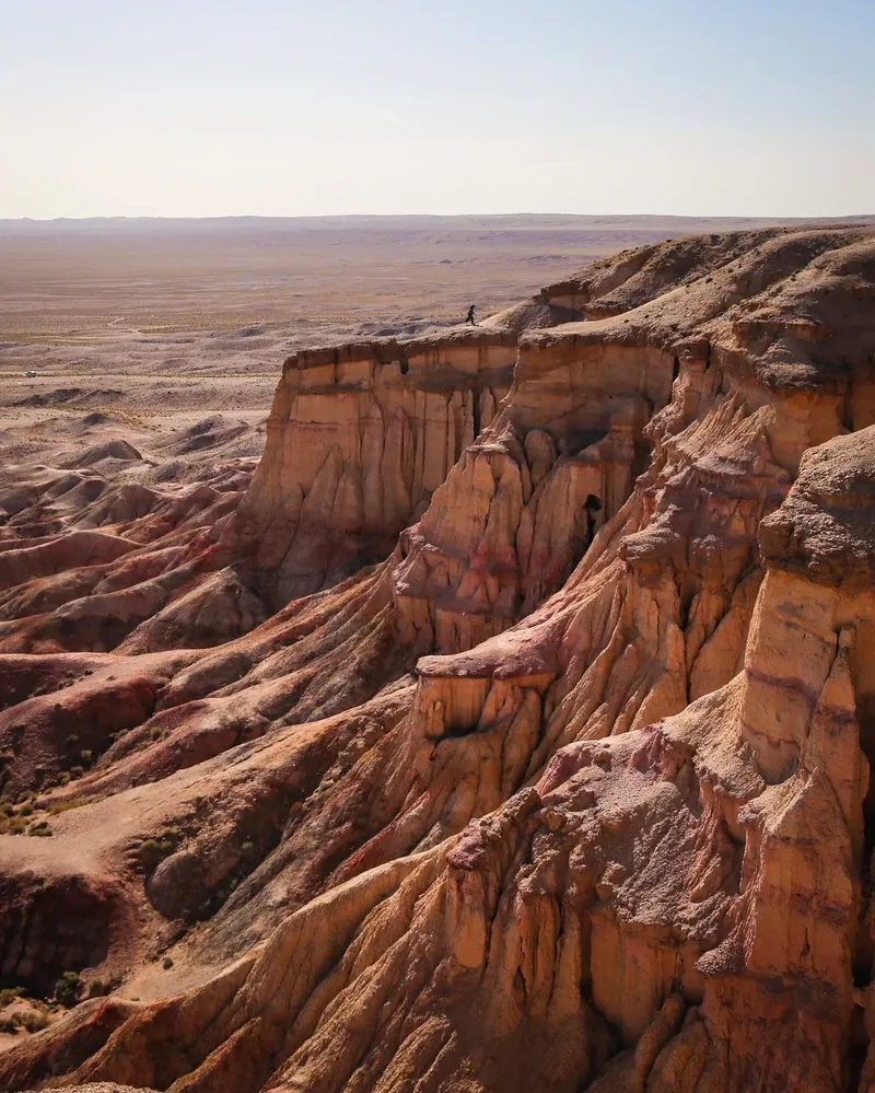
An ancient inland sea covered this region millions of years ago. Receding waters left behind massive limestone formations like Tsagaan Suvarga, which now resemble the ruins of a white city rising 30 meters above the desert floor. By the 4th century, Buddhist monks began carving the Mogao Caves into the cliffs near Dunhuang on the desert's Chinese edge. These 492 temples became a major spiritual hub along the Silk Road, housing thousands of square meters of murals. Caravans of two-humped Bactrian camels crossed the gravel plains, moving silk, spices, and ideas between East and West. The Jiayuguan Pass, built 4.5 hours from Dunhuang, marked the westernmost end of the Ming Dynasty Great Wall and controlled trade flowing into the desert. Soldiers stationed at this fortress monitored merchant traffic and defended the agricultural lands from nomadic raids.
Genghis Khan unified the nomadic tribes in the 13th century. The desert served as the central territory and a natural fortress for the Great Mongol Empire. Mongol cavalry navigated the extreme terrain, utilizing scattered oases to sustain their campaigns across Eurasia. The harsh environment protected their heartland from southern invasions. Nomadic herders continued to live in portable felt gers, moving with the seasons to find sparse grazing for their livestock. Monastic centers later grew along the riverbanks. The Ongii Monastery, established in the 18th century, housed over 1,000 monks before political purges destroyed the complex in the 1930s. The ruins still sit exposed on the banks of the Ongi River, four hours from Bayanzag.
Roy Chapman Andrews led an expedition from the American Museum of Natural History into the Mongolian interior in 1923. His team reached the red sandstone formations of Bayanzag, later named the Flaming Cliffs due to their bright orange color at sunset. They unearthed the world's first confirmed fossilized dinosaur eggs. This discovery proved that dinosaurs laid eggs and turned the region into a global center for paleontology. Expeditions continue to find Protoceratops and Velociraptor skeletons preserved in the sandstone. Today, Mongolia strictly protects these fossil beds. You cannot dig or remove any bones found on the surface. Most significant finds are now displayed at the Central Museum of Mongolian Dinosaurs in Ulaanbaatar.
UNESCO designated the Mogao Caves a World Heritage site in 1987. Six years later, Mongolia established the Gobi Gurvan Saikhan National Park to protect the desert's unique ecosystem. The park charges a 3,000 MNT entrance fee and safeguards habitats for over 50 mammal species, including snow leopards, Gobi bears, and wolves. Foreign visitors heading to the 30-kilometer zone near the Mongolia-China border must secure a special military permit in Ulaanbaatar before departure. Drones require real-name registration in China and face strict flight bans near these border zones. Always carry physical copies of your passport and visa when traveling near the frontier.
Gravel plains and rocky outcrops define 95 percent of the landscape. The terrain sits on a massive plateau elevated between 910 and 1,520 meters above sea level. Wind erosion shapes the exposed bedrock into sharp ridges and deep canyons. Yolyn Am, or Vulture Valley, cuts so deeply into the Gurvan Saikhan Mountains that sunlight rarely reaches the bottom. A thick ice field persists inside this narrow gorge well into the summer months. Visitors walk through the freezing canyon walls, watching bearded vultures circle the peaks 200 meters above. Stinging nettles grow thick near the stream bed. Brushing against these plants causes immediate skin irritation.
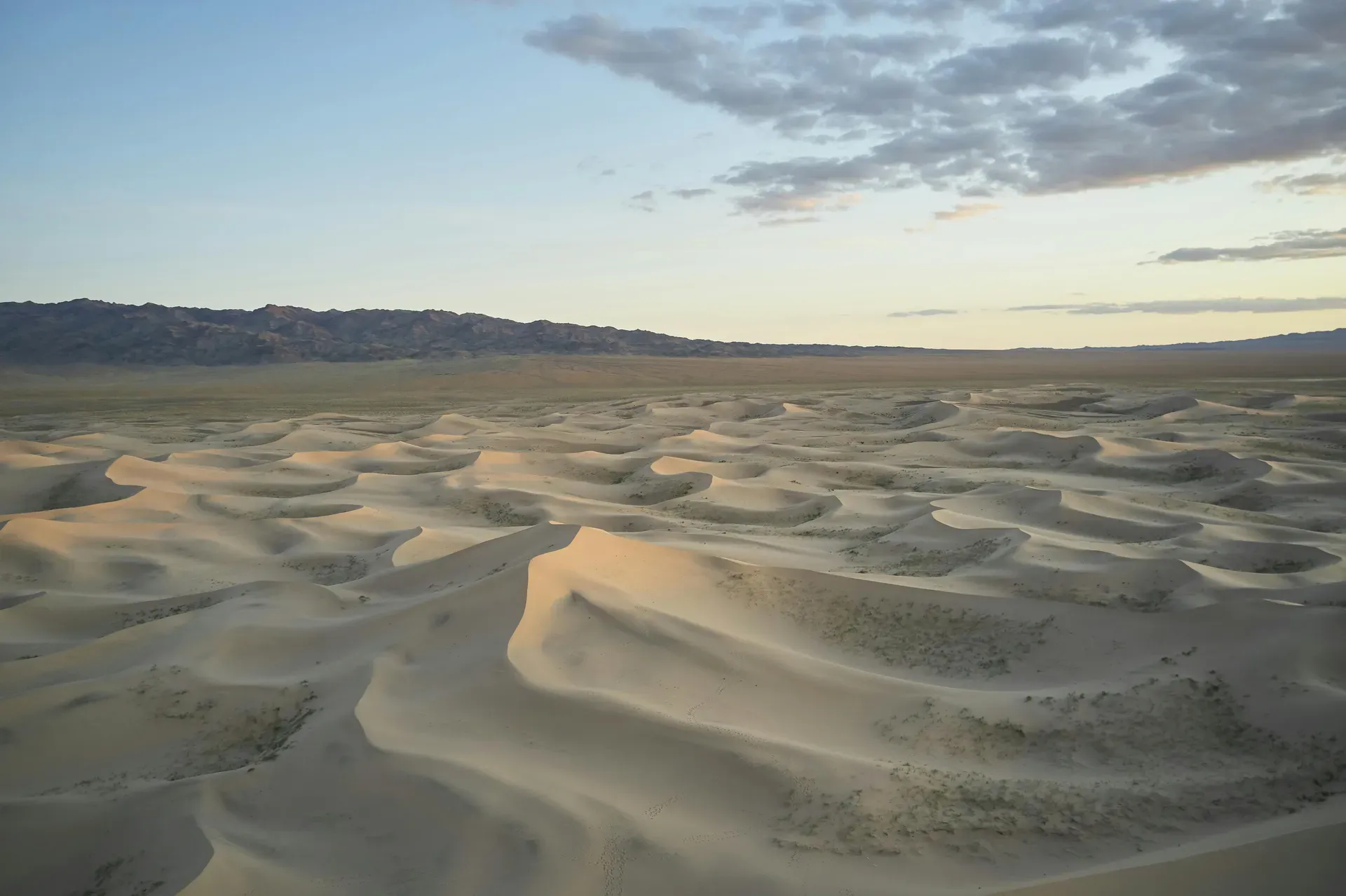
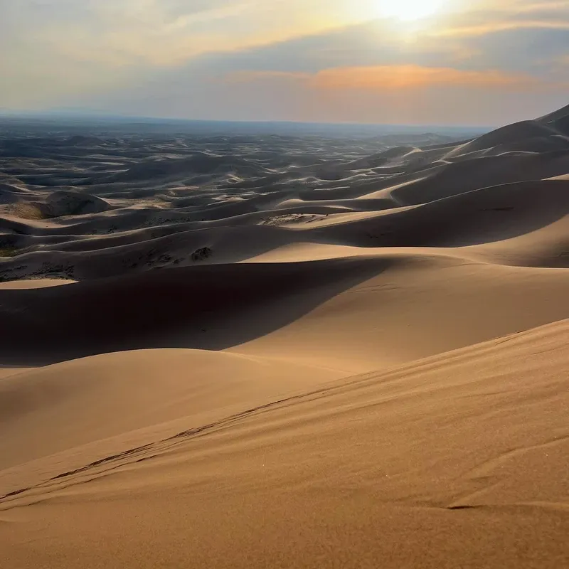
The Khongoryn Els sand dunes stretch for 100 kilometers along the desert floor. These peaks rise up to 300 meters high and consist of loose, shifting grains. Wind moving across the ridges creates a distinct humming noise, earning them the name "Singing Sands." Climbing to the summit requires an hour of strenuous effort, as every step forward results in sliding half a step back. The descent takes just minutes. The fine dust from these dunes frequently whips into the air during sudden gusts. Carry a scarf or face mask to protect your lungs. The sand absorbs heat rapidly, making afternoon climbs dangerous in July.
Red sandstone dominates the Flaming Cliffs at Bayanzag. The iron-rich rock glows bright orange and crimson during sunset. The loose soil here constantly erodes, exposing new fossils after heavy winds. Across the border in China, Mingsha Mountain surrounds Crescent Lake. This natural oasis has maintained its crescent shape and water level for over 2,000 years. Underground springs feed the lake, preventing the surrounding 250-meter dunes from burying the water source. The site opens at 05:00 from May to October, allowing visitors to watch the sunrise over the water before the midday heat sets in. Entry costs 110 RMB, and the ticket includes access to the surrounding dune trails.
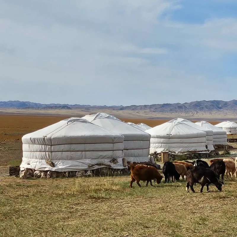
Nomadic herders have adapted to the extreme climate for millennia. Families live in circular gers, moving their camps several times a year to find fresh pasture for camels, goats, and sheep. The two-humped Bactrian camel remains essential for transport and wool production. Locals celebrate their heritage during the annual Naadam festival in July, competing in wrestling, horse racing, and archery across the steppe. Bringing small gifts like school supplies or high-quality tea helps establish goodwill when visiting a nomadic family's camp. You will often hear the low grunts of camels outside the tent as you drink tea.
Buddhist traditions run deep in the desert's isolated pockets. The ruins of Ongii Monastery sit on the banks of the Ongi River. Before its destruction in the 1930s, this complex housed over 1,000 monks and served as a major religious center. Visitors to active temples must wear modest clothing covering shoulders and knees. Inside a ger, strict customs dictate behavior. You must never step on the wooden threshold, always move clockwise around the central stove, and accept a bowl of fermented mare's milk with your right hand. Pointing your feet at the central fire is considered highly disrespectful.
The night sky holds deep cultural importance for navigation and storytelling. Zero light pollution allows for completely unobstructed views of the Milky Way from remote camps. Constellations guide herders across trackless plains during nighttime travel. Sacred water sources dot the landscape, marked by blue silk scarves tied to nearby rocks or branches. Littering near these springs is strictly forbidden and deeply offensive to local customs. Always ask permission before photographing monks or nomadic families. A simple nod or verbal request prevents awkward confrontations in isolated camps.
The vast majority of the landscape consists of bare rock, dry steppe, and gravel plains.
Roy Chapman Andrews discovered the first fossilized dinosaur eggs here in 1923.
Yolyn Am gorge is so deep and narrow that it contains thick ice even in mid-summer.
The region is the native home of the Bactrian camel, built to survive extreme cold and heat.
The 300-meter-high Khongoryn Els dunes emit a loud humming sound when wind moves the sand.
The Himalayas block Indian Ocean moisture, causing the desert's extreme dryness.
Remote ger camps offer completely unobstructed views of the Milky Way.
No, only about five percent of the area is covered by sand dunes. The remaining 95 percent consists of rocky plateaus, gravel plains, and dry grass steppe.
Temperatures regularly drop to -40°C between December and February. The high elevation and lack of geographical barriers allow freezing Siberian winds to sweep across the plains.
Tap and stream water are not safe for consumption. You must drink bottled or boiled water, which costs roughly 1,500 MNT per 1.5-liter bottle at local shops.
Yes, navigating the trackless terrain requires a local driver and guide. GPS signals frequently fail off-road, and getting lost poses a severe risk of dehydration.
A ger is a portable felt tent used by nomadic herders. Tourist camps use modified versions equipped with beds and central wood-burning stoves for heating.
Cellular signal exists in provincial centers like Dalanzadgad but disappears completely in remote areas. You will not have internet access at the dunes or deep valleys.
Ger camps generate electricity using solar panels or diesel generators. They typically provide power for just a few hours each evening using 220V European-style outlets.
Wildlife encounters are rare, but the ecosystem supports wolves, snow leopards, and the Siberian pit viper. Stinging nettles also grow in some valleys and cause skin irritation.
Traveling within 30 kilometers of the Mongolia-China border requires a special military permit. Foreigners visiting the Chinese side need a standard tourist visa.
While you can visit famous excavation sites like the Flaming Cliffs, you cannot dig or remove fossils. The most significant discoveries are housed in the Central Museum of Mongolian Dinosaurs in Ulaanbaatar.
Browse verified tours with free cancellation and instant confirmation.
Find Tours